koh logo
Showing posts with label Phangnga. Show all posts

Saturday, January 27, 2007

Khao Lampi - Hat Thai Mueang National Park


Khao Lam Pee-Khao Tai Muang National Park is formerly so called "Lam Pee Waterfall" prior to The Royal Forest Department established it as "Lam Pee Forest Park" and assigned to manage and control by the National Park Division on April 14, 1986. It is the 52th national park of Thailand which cover area of 72 square kilometers or 45,000 rais.

Location and Journey

Khao Lampi - Hat Thai Mueang National ParkMu 5, Thai Muang Sub-district,, Thai Muang, Phangnga, Thailand 82120

Tel. : 0 7641 7206 Fax : 0 7641 7206

By Car
Using the 3 roads : the road no. 4th, no. 401th and no. 402th.

By Airplane
Since Phang Nga just far from Phuket airport only 66 kilometers, therefore you can easily take a plane to Phuket and then take a car to Phang Nga on the road no. 4th which only 57 kilometer to Tai Muang market and then drive for 6 kilometers to the national park office.

By Bus
Uses service of Bangkok-Phang Nga line of the bus company. It costs you about 425 baht for a normal bus and 495 baht for an air-conditioning bus. From Phang Nga to the national park, about 62 kilometers, you can take a normal bus, costs about 30 baht, or take an air-conditioning bus which costs about 45 baht or small bus which costs only about 20 baht.


Saturday, January 13, 2007

Khao Lak-Lam Ru National Park, South Island Thailand


n the past this national park is only the sea shore forest park of Khao Lak, until Mr. Somchit Suksanga, village chief of Mu 3, Kapong sub-district, Kapong, Phang Nga, had proposed to the assistant minister of agricultural and cooperative on september 26, 1984 for considering to declare the forest of Amphoe Ka Pong and nearby forest to be the conservation forest for conserving the origin or source of water of Phang Nga province which still be the perfect forest and has a lot of wild animals. Morever, this area still has a colorful tourist attraction, especially many small waterfalls. This area became the 66th national park on August 30, 1991 namely "Khao Lak -Lam Ru Natitonal Park covers 125 squarekilometre


Geographical Features
General geograhy consists of many moutains such as Lak mountain, Lam Ru mountain, Sang Tong mountain, Mai Kaeo mountain and Prai Bang Toa mountain. The highest peak is about 1,077 meters about the sea level which is the origin of the important rivers of Phang Nga province, namely Ta Kua Pa river and Phang Nga river and also consisting of many small canals and streams. The Khao Lak - Lam Ru national park office is located in the shore area nearby sea covering the rock beach ecological system, sand beach and coral ecological system.

Weather Condition


The Khao Lak - Lam Ru national park is located in the western coast of Andaman sea, let it get an influence of southwestern monsoon wind and northeastern monsoon wind which induce to have raining for almost all year round. It's two seasons, hot season starting from January till April and raining season starting from May till December which would have a lot of rainfall.


Varieties of Plants and Wild Animals


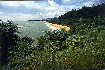
The majority of the park is covered by Tropical evergreen forest, some is still pristine, whereas in other areas human encroachment has altered the forest structure. In some places the original forest has been completely replaced by fruit trees or rubber plantations. The park also has some small areas of coastal habitat and small secluded sandy beaches.

Tropical evergreen forest, this occurs on the forested hills of Khao Lak. In places with little human disturbance this forest is highly differentiated with; a ground flora, an undergrowth of seedlings, then a canopy of three levels, lower, intermediate and upper and above this a few emergent forest giants. The principle tree species recorded include; Dipterocarpus sp., Alstonia scolaris, Anisoptera costata, Michelia champaca, Syzygium sp., Hopea odorata, Mimusops elengi, several palm (Palmae) species and Bamboo (Gramineae). This forest is also very rich in epiphytes such as Orchids and ferns, and snaking between the trees are Lianes and many climbers including Rattans.

In small patches near the coast the forest includes many marine tolerant species including; Barringtonia asiatica, Anacardium occidentale and Pandanus odoratissimus.

Wild Animals
Mammal animals consists of Colugo, Binturong, Malaysian weasel, Drynaria. bonii H. Christ, Bat and the big mammal animals found here are. Sumatran serow, Malayan Tapir, etc.

Retiles could be classified into the daytime living reptiles such as Idian or Bengal Monitor, etc. and the reptiles that you could find directly are Snake such as Iridescent earth snake, Malayan pit viper, and White-lipped pit viper.

Amphibians such as Bufo asper Gravenhorst, Rana laticeps Boulenger, and Heymon's Froglet, etc.

Birds, from survey could be classified into 15 class-orders 108 families, for example Crested serpent-eagle, White-bellied sea-eagle, Emerald Dove and Scarlet Minivet , etc. while the big birds could be found 3 types, namely Bushy-crest hornbill, Oriental pied hornbill, and Homrai.

Daytime butterflies, most of them could be found in the primary rainforest, especially in the creek or pond area. The daytime butterflies are defined as conserved animals totally 3 types, namely Troides aeacus thomsoni, Troides amphrysus ruficollis, and Stichophthalma godfreyi.

Sea animals , for example the sea cucumber group such as Black Cucumber, H. scabra, etc. , the hedgehog group such as Malayan Porcupine, etc., the sea slug such as Feather star, etc., the fish group such as Morey eel, Lizardfish, Long Tom, etc., the star group such as Feather star, the crab group such as Giant murex, Tiger Cowrie.
Location and Journey
Address
Khao Lak-Lam Ru National Park
Mu 7, Khuek Khak Sub-district,, Takua Pa, Phangnga, Thailand 82190
Tel. : 0 7648 5243 Fax : 0 7648 5414

By Car

You can drive from Bangkok on the road no. 4 (Phetchakasem Road) until arrive at Khao Lak-Lam Ru National Park which located only 50 meters from the road. Please notice Pho Ta Khao Lak spiritual house which be respected by local people.


By Airplane

Fly to Phuket international airport and take a bus to the Khao Lak-Lam Ru National Park by using the Petchakasem road direct to Amphoe Thai Muang.


By Bus

Takes a bus at the southern bus terminal, select one of an air conditioning buses or normal bus routed from Bangkok-to-Phuket and Bangkok-to-Takuapa or Bangkok-to-Phang Nga which cost you about 357 baht for a normal bus, 459 baht for an air condition bus and baht 685 for a special air condition bus.


Thursday, January 4, 2007

Ao Phang-nga National Park , South Island


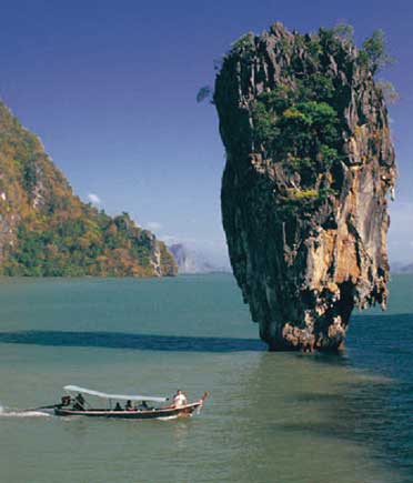
Believe It or Not Tabu Island was created because of anger. There is a local story that said : once upon a time, there was a fisherman who normally caught a lot of fish everyday for selling at the market. One day, as usual, he went to net, but it was not his day. He threw his net many, many times but got nothing. With great patience he tried again and again, but still got nothing. Consequently, he stared at the water looking for a waving pattern, he then threw his net again with a lot of hope. He kept his eyes fixed on the net when pulling it up, hoping some fish would be caught. Unfortunately he caught nothing but a nail. He became angry and threw the nail into the sea. Again with great concentration, he kept his eyes on the sea surface and tried his net once more. This time he threw his net as wide as he could with great hope of getting some fish. Then he pulled it up slowly as it was very heavy. He pulled it up with great care. At the end of the net he found the only thing caught was the same nail.He was so angry, he grasped his long knife and cut the nail with all his strength. The nail was cut in half. The nail was catapulted away and driven into the buttom of the sea standing up as you see it today.The area around Phangnga bay has a long history and is famed for its nature and beauty, especially Ko Tabu, Ko Panyi, Tham Lot and Khao Phing Kan. The rock art in this area has always been an important attractionThe popularity of the Phang Nga bay area led to the designation of the current area as a forest park in 1974, this was named Sri Phang Nga Forest Park. The Royal Forest Department then began to survey the area and realised it's heritage should be further protected by increasing the areas status to a national park.Ao Phangnga was created by Royal decree and gazetted under proclaimation number 98 section 64 of 29th April 1981. The park created covers an area of 400 sq.km, protects the largest area of this original primary mangrove forest remaining in Thailand. The park stretches from Muang Phangnga District to the coast at Takua Tung District. Over 80 % of the park is covered by the Andaman sea, with over 42 large and small islands, including such as Phra At Tao Island, Maprow Island, Boi Noi Island, Boi Yai Island, Rayaring Island, Phanak Island, Hong Island, Panyi Island, Phing Kan Island etc.
Geographical Features
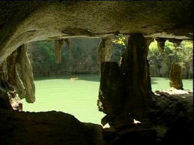
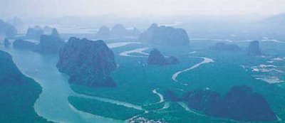
The topography of the park is strongly influenced by several faults, particulary the north-east trending of the Klong Marui fault. This offsets the eastern terrain from the central mountain ranges by a right lateral movement. This fault movement resulted in the formation of a large graben parallel to the fault. This graben is marked by the present bay.The high ground is produced by massive limestone blocks displaying classic karst scenery. These blocks extend southward into Phangnga bay where they form islands with vertical cliffs, mainly orientated in a north-south direction.Phangnga bay slopes seaward and is filled with tidal sediments. The bay itself is composed of large and small tidal channels which originally connected with the fluvial system of the mainland.The main tidal channels for instance Klong Ko Panyi, Khlong Phangnga, Klong Bang Toi and Klong Bo Saen all run in a north-south direction. They consist of several tidal creeks or tidal channel distributaries. Most of the tidal channels are meandering with well developed point bars. Mangrove forests grow around the whole area of the Phangnga bay, they differ in species depending on elavation and relative tidal range.The landward boundary of Phangnga bay is marked by a gentle erosion slope, limestone cliffs and transition forest between mangrove and upland forest which extends beyond the bay margin.
Weather Condition
The climate experienced in Phangnga Bay is tropical marine, with characteristic high rainfall and year round high temperatures. Thirty year records of Meteological Department of Thailand (1961-1990) collected at Takua Pa weather station indicate that rain is abundant in the south-west monsoon season from May to October. The average annual rainfall is 3,560.5 mm. and the average total rain days is 189 days. The temperature fluctuates between 23๐C and 32๐C. The average relative humidity is 83%.
Varieties of Plants and Wild Animals
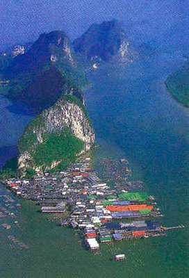
VegetationsPlant society in the Phang Nga Bay National Park could be divided into 3 types as follows :

Mangrove ForestMangrove forest in the limestone mountain which found a lot of important plants in mangrove forest upto 12 types such as Rhizophora mucronata, Rhizophora apiculata, Xylocarpus granatum, etc. In addition, also found sea holly and a lot of Acrostichum aureum which growing up in the bank area or mud soil. Sea cyad is found a little bit in only the oponed area or destroyed area.

Mangrove forest in the cell and quatsite rock mountain which found the 7 important types of plants such as Rhizophora mucronata, Rhizophora apiculata, Xylocarpus granatum, etc. The other important low level plant found in this area is the dense growing sea holly.Mangrove forest in sandstone mountain which found a little bit of important plants because this area is very far from the main land. The 5 types of important plants here are Rhizophora apiculata, Sonneratia ovata, Aegialites rotundifolia, Xylocarpus granatum and Melaleuca leucadendron. In addition, samed would be found in the area adjacent to land forest which has the lower salt level.

Land Forest, Defined as the evergreen forest which is rainforest and classified as follows :Land forest on the limestone mountain which could be found throughout the national park, there are 2 types :

the first is the forest on the plain land and the forest on the area so called Karst which is a valley area. They consist of the important plants such as Aporosa aurea, Hopea ferrea Heim. and Cassia alata Linn. Also, there are many important low level plants such as Fishtail palm.

The second is the forest on the moisture high area on a limestone mountain which consists of small and short plants such as Hopea ferrea Heim., Water wisteria, etc. Land forest on the cell quatsite rock mountain which found a lot of plants growing in the foot of mountain with very high moisture, we can find yang na woods scattering throughout this area and also find other important plants such as Schima wallichii (DC.) Korth., Bruguira gymnorrhiza, Carallia brachiata (Lour.) Merr., etc. while the low level plants found here are Bambusa arundinacea Wild, Glass, etc.Land forest on a sandstonewould be found on the slope area which has a lot of tree and not too high. There is a little bit of the low level plants here, most of them are grasses because of infertile soil. The important plants are Bruguira gymnorrhiza, Sesban, etc.
Aquatic Plant SocietyCould be classified as Padina, red alge, Halimida and including a lot of sea grass and plant planton.


Wild Animals, From survey could be classified as follows :Mammal animals, from survey could be found upto 27 types such as Macaca irus, Semnopithecus obscurus, Hylobates lar, etc. In addition, also found the important aquatic mammal animals such as Infonesian white dolphin, Malayan dolphin, Finless porpoise.Birds have been found totally 120 types, the important ones are Little heron, Pacific reef-egret, Little egret, etc.Reptiles have been found totally 26 types such as Siamese box terrapin, Pseudoxenodon macrops (Blyth), etc.Amphibians have been found 4 types such as Rana cancrivora, R. limnocharis, Rhaco phorusleucomystax, etc.Fishes consists of squat-headed hammer head shark sphyrna tudes, freshwater ater stingray dasyatis bleekeri, Moray eel, Puffer fish and many kinds of fish which live in the coral such as Butterfly fish and the economical valued fishes such as short-bodied mackerel.Marine LifeMarine life totals over 80 species: 24 species of fish, 14 species of shrimp, 15 species of crabs and another 16 species of manta-rays, sharks, and gamefish. In the bay, you will find blue crabs, swimming crabs, mud-skippers, humpback shrimp, mud-lobsters, pomfrets, jewfish, sole, anchovies, scad, rock cod, as well as rainbow cuttlefish, soft cuttlefish, musk crab, mackerels, spinefoots, groupers, black sea cucumbers, brain coral, staghorn coral and lastly flowerlike soft coral.The bay of Ao Phangnga National Park has a wealth of plankton, these are small plant and animal organisms that float at the water surface and serve as food for many species. The presence of large amounts of plankton is due to the shallowness of the water, rich nutrient supply and the higher temperatures found in the bay area. As the food resource is high, this makes a good nursery area for mothers of many species, which enter the bay to rear their young before returning to deeper water
Location and Journey

Address
Ao Phang-nga National Park80, Mu 1, Ban Tha Dan, Ko Panyi Sub-district,, Muang Phang Nga, Phangnga, Thailand 82000Tel. : 0 7641 1136, 0 7641 2188 Fax : 0 7641 3791
By Car
Once in Phang nga Town , go past on highway heading to Takua Thung District, pass the provircial Hall. About after 850 kilometers,at three junction,you turn left about 2.5 kilometers.
By Airplane
Takes a plane to Phuket International Airport, for about 1 hours 15 minutes, and then connect a car for 61 kilometers which takes time about 45 minutes to Phang Nga town. After that takes a minibus, Phang Nga-Tha Dan route, for 9 kilometers and will find it priot to Ta Dan 300 meters.
By Ship
Rent a boat or contact tour agent to handle for you.

Wednesday, December 6, 2006

Mu Ko Surin National Park


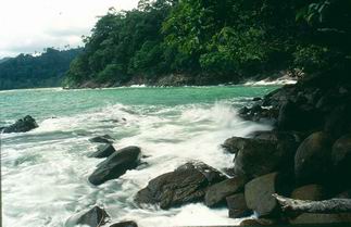
Surint Islands comprise of five main islands, including 2 large islands consisting of the northern surint island and southern surint island which located very adjacent like the twin island. They are separated by the 200 meters width shallow sea. In the low tide period, you can walk across to the other island or so-called "cutted channel bay". The other three islands are the rock islands with some dwarf trees. Plants that found here are the rainforest plants. They are one source of the big and best fertile shallow coral reef of Thailand
Could be classified into 2 seasons consisting of hot seasons starting from mid of February - May, while the raining season starting from mid of May till October which has a highest level of rainfall. The yearly average rainfall is more than 3,000 milimeters and the average of related humidity is 83 percent. In rainy season, the national park will be closed during 16 May - 15 November every year for visitors safety.

Location and Journey
Mu Ko Surin National Park
Khura Sub-district,, Khuraburi, Phangnga, Thailand 82150
Tel. : 0 7649 1378, 0 7649 1582 Fax : 0 7649 1583

By Car
Drives on the road no. 4 (Phetkasem Rd.) from Bangkok to Amphoe Khuraburi which is about 720 kilometers long then turns to Khuraburi Port at milestone no. 721, about 6 kilometers prior to Amphoe Khuraburi. From this intersection about two kilometers, you would see the entrance sign board of Mu Ko Surin National Park on the right-hand side, then make a turn to the tourist service center which located in the area of national park office.


By Airplane
Takes a plane to Ranong Airport or Phuket Airport, then takes a car to Amphoe Khuraburi of Phang Nga province.


By Ship
At Khuraburi - Mu Ko Surin Port, you can take a private tour boat which controlled by the national park and serves tourists everyday. The cost for round trip is 1,100-1,700 baht per person. This tour boat departs from Kuraburi Port at 09.00 am. everyday and arrive at the National Park Headquarters unit on Northern Mu Ko Surin at 11.30 pm. From the port to this islands is about 60 kilometers which takes about 2.30 hours of journey. The return boat from Mu Ko Surin to Khuraburi Port departs at 13.00 am. everyday. However, this service would be closed at May 16 every year because entering of raining season.


By Bus
Starts from the New Southern Bus Terminal at 7.00 pm which would arrive at Khuraburi about 5.00 am. Bus fare is 480 Baht/person. From the Bus Terminal, in Amphoe Khuruburi about 10 kilometer, you can take a motorcycle or rental car to the Khuraburi Port area, the location of Mu Ko Surin National Park Office. Motorcycle fare is about 50 Baht/person while a rental car cost you about 200 Baht/person

Tuesday, December 5, 2006

Mu Ko Similan National Park


Consists of numerous islands with high and steep granite mountain, beaches and rocks formation of many shapes. The shoreline of each islands are of inconsistent curves since they are situated in the outer part of the sea and are worn away directly by waves. Part of the water lies in the Andaman Sea and eastern side of the Indian Ocean while the shoulder of the continent borders the western shoreline of Phang Nga province and Union of Myanmar, paralleling the Nikobar Islands of India. There is no mud at all along the beaches, so the sands are very clean, white and very fine. Some islands do have hills in the area, which are usually quite tall with the highest top of 244 meters above mean sea level, while some islands are of flat area surrounded by sand dunes and coral reefs.


Mu Ko Similan National Park has been rated first by the U. S. publication Skin Diving of the top ten dive sites in the world. The Similan Islands in the heart of the Andaman Sea are indeed unparelled in their exotic beauty. If planning a visit, keep in mind that anytime between December to April is recommended, with the best month being March, because the monsoons are over and the water is clear.

Location and Journey
Address
Mu Ko Similan National Park93, Mu 5, Ban Thaplamu, Phetkasem rd, Lamkaen Sub-district,, Thai Muang, Phangnga, Thailand 82210Tel. : 0 7659 5045 (บนฝั่ง), 0 7642 1365 (บนเกาะ 4) Fax : 0 7659 5210
By Car
There are daily bus services from Bangkok to Phang Nga (approximately 788 kilometres)
Standard bus fee is 357 Baht, air-conditioned bus fee is 459 Baht, and VIP air-conditioned bus fee is 685 Baht.Then another 65 kilometres from Phang Nga to Thap Lamu District, it cost 35 Baht. for Motorbike can then be taken to continue on to Thap Lamu Pier (another 5 kilometres) at 30 Baht.
By Airplane
Flights from Bangkok-Phuket operate daily at 2,300 Baht. From Phuket, take a bus to Thap Lamu Pier, Phang Nga province then take a ferry to Mu Ko Similan National Park.
By Ship
Thap Lamu Port to Mu Ko Similan National Park, you can take a private tour boat which controlled by the national park and serves tourists everyday. The cost for round trip is 1,500 - 2,300 baht per person. This tour boat departs from Thap Lamu Port at 08.30 am. in everyday. From the port to this islands is about 70 kilometers which takes about 3.5 - 4 hours of journey. The return boat from Mu Ko Similan National Park to Thap Lamu Port departs at 13.00 pm. and 15.00 pm. in everyday. However, this service would be closed at May 16 every year because entering of raining season. Once reached Ko Similan, motorboats are available for tourist to get to different islands per the following fare


Monday, December 4, 2006

Mu Ko Ra - Ko Phra Thong National Park


In general, the area, located the west of Phangnga Province, consists of sinking seashore and productive mud-beaches on estuaries of many long rivers. The area is influenced by ebb and high tide of the sea. There are high mountains and islands lie north and south such as, Ra Island with the mountains about 235 meters above sea level, Phra Island with plain area, Kho Khao Island with high mountain about 310 meters above sea level, and many small islands such as Pling Island, Tachai Island and Bosai Island which has the highest mountain about 450 meters above sea level.
Location and Journey
Mu Ko Ra - Ko Phra Thong National Park
Ko Phra Thong Sub-district,, Khuraburi, Phangnga, Thailand 82150
Tel. : 0 7649 1378, 0 7649 1582
By Car
Be able to go there by cars, from Bangkok by using a superhighway number 4 as far as Kuburi District then going to the piers for traveling to other islands.
By Ship
There are many piers such as Nang Yon Pier; nearby Visitor Center of Mu Ko Surin Nayional Park, Ban Nam Khem Pier in Takuapa District where can go to Ko Kho-Khao for only 30 minutes, Ban Tung La-ong Pier where can go by a long-tail boat to the south of Ko Phrathong for 20 minutes and to the north of Ko Kho-Khao for 20 minutes.