koh logo

Saturday, January 27, 2007

Khao Lampi - Hat Thai Mueang National Park


Khao Lam Pee-Khao Tai Muang National Park is formerly so called "Lam Pee Waterfall" prior to The Royal Forest Department established it as "Lam Pee Forest Park" and assigned to manage and control by the National Park Division on April 14, 1986. It is the 52th national park of Thailand which cover area of 72 square kilometers or 45,000 rais.

Location and Journey

Khao Lampi - Hat Thai Mueang National ParkMu 5, Thai Muang Sub-district,, Thai Muang, Phangnga, Thailand 82120

Tel. : 0 7641 7206 Fax : 0 7641 7206

By Car
Using the 3 roads : the road no. 4th, no. 401th and no. 402th.

By Airplane
Since Phang Nga just far from Phuket airport only 66 kilometers, therefore you can easily take a plane to Phuket and then take a car to Phang Nga on the road no. 4th which only 57 kilometer to Tai Muang market and then drive for 6 kilometers to the national park office.

By Bus
Uses service of Bangkok-Phang Nga line of the bus company. It costs you about 425 baht for a normal bus and 495 baht for an air-conditioning bus. From Phang Nga to the national park, about 62 kilometers, you can take a normal bus, costs about 30 baht, or take an air-conditioning bus which costs about 45 baht or small bus which costs only about 20 baht.


Monday, January 15, 2007

Hat Noppharat Thara , South Island


The Royal forest department had surveyed and established the 75 million-year shell cemetery (Susan Hoi), Hat Noppharat Thara - Mu Ko Phi Phi and near-by islands in Nong Thale sub-district, Ao Nang sub-district, SaiThai sub-district and Pak Nam sub-district of Amphoe Mueang Krabi, 389.96 sq.km, as the 47th National Park of Thailand so called "Hat Noppharat Thara-Mu Ko Phi Phi National Park". There after, it had been expanded to cover the shell cemetery and near-by islands, 0.02 sq.km. After that the area of Nong Thale sub-district, Amphoe Mueang Krabi, Krabi province which is the area of the Royal Thai Navy and the Royal Palace area has been excluded from this national park and left only 387.90 sq.km.

Geographical Features
Consists of the land area on the coast of the island such as Ao Nammao mountain area, Ao Nang-Hang Nak forest and other islands. The geological form of this area is the high mountain laid along the northwest-southeast direction. Coast area is the high mountain while the western side has deeper slope than the eastern side. Geological form of sea coast area and islands in Andaman sea would be affected by the line of earth layer movement so called "Indosenia Teotonic Movement". At the area of mangrove forest of Hang Nak mountain you would find the Klom mountain canal on the coast rim which get the drained water from a big pond, so called "Nong Thale" (Sea Pond) and originates the mangrove forest and low plain area of the Samed forest in the area of national park office namely "Khlong Haeng" (Noppharat Thara Beach).


Weather Condition

"Hat Noppharat Thara - Mu Ko Phi Phi National Park is influenced by tropical monsoon wind. During November-October would has the southeastern-monsoon wind drives through and induces to have two seasons of weather here; the first is raining season starts from May till December and the hot season starts from January till April. Average temperature here is about 17 - 37 degrees celsius. Average rainfall per year is about 2,231 milimeters which would be highest in July and lowest in February.

Location and Journey


Address
Khao Lak-Lam Ru National ParkMu 7, Khuek Khak Sub-district,, Takua Pa, Phangnga, Thailand 82190Tel. : 0 7648 5243 Fax : 0 7648 5414
By Car
You can drive from Bangkok on the road no. 4 (Phetchakasem Road) until arrive at Khao Lak-Lam Ru National Park which located only 50 meters from the road. Please notice Pho Ta Khao Lak spiritual house which be respected by local people.
By Airplane
Fly to Phuket international airport and take a bus to the Khao Lak-Lam Ru National Park by using the Petchakasem road direct to Amphoe Thai Muang.
By Bus
Takes a bus at the southern bus terminal, select one of an air conditioning buses or normal bus routed from Bangkok-to-Phuket and Bangkok-to-Takuapa or Bangkok-to-Phang Nga which cost you about 357 baht for a normal bus, 459 baht for an air condition bus and baht 685 for a special air condition bus.

Saturday, January 13, 2007

Khao Lak-Lam Ru National Park, South Island Thailand


n the past this national park is only the sea shore forest park of Khao Lak, until Mr. Somchit Suksanga, village chief of Mu 3, Kapong sub-district, Kapong, Phang Nga, had proposed to the assistant minister of agricultural and cooperative on september 26, 1984 for considering to declare the forest of Amphoe Ka Pong and nearby forest to be the conservation forest for conserving the origin or source of water of Phang Nga province which still be the perfect forest and has a lot of wild animals. Morever, this area still has a colorful tourist attraction, especially many small waterfalls. This area became the 66th national park on August 30, 1991 namely "Khao Lak -Lam Ru Natitonal Park covers 125 squarekilometre


Geographical Features
General geograhy consists of many moutains such as Lak mountain, Lam Ru mountain, Sang Tong mountain, Mai Kaeo mountain and Prai Bang Toa mountain. The highest peak is about 1,077 meters about the sea level which is the origin of the important rivers of Phang Nga province, namely Ta Kua Pa river and Phang Nga river and also consisting of many small canals and streams. The Khao Lak - Lam Ru national park office is located in the shore area nearby sea covering the rock beach ecological system, sand beach and coral ecological system.

Weather Condition


The Khao Lak - Lam Ru national park is located in the western coast of Andaman sea, let it get an influence of southwestern monsoon wind and northeastern monsoon wind which induce to have raining for almost all year round. It's two seasons, hot season starting from January till April and raining season starting from May till December which would have a lot of rainfall.


Varieties of Plants and Wild Animals


The majority of the park is covered by Tropical evergreen forest, some is still pristine, whereas in other areas human encroachment has altered the forest structure. In some places the original forest has been completely replaced by fruit trees or rubber plantations. The park also has some small areas of coastal habitat and small secluded sandy beaches.

Tropical evergreen forest, this occurs on the forested hills of Khao Lak. In places with little human disturbance this forest is highly differentiated with; a ground flora, an undergrowth of seedlings, then a canopy of three levels, lower, intermediate and upper and above this a few emergent forest giants. The principle tree species recorded include; Dipterocarpus sp., Alstonia scolaris, Anisoptera costata, Michelia champaca, Syzygium sp., Hopea odorata, Mimusops elengi, several palm (Palmae) species and Bamboo (Gramineae). This forest is also very rich in epiphytes such as Orchids and ferns, and snaking between the trees are Lianes and many climbers including Rattans.

In small patches near the coast the forest includes many marine tolerant species including; Barringtonia asiatica, Anacardium occidentale and Pandanus odoratissimus.

Wild Animals
Mammal animals consists of Colugo, Binturong, Malaysian weasel, Drynaria. bonii H. Christ, Bat and the big mammal animals found here are. Sumatran serow, Malayan Tapir, etc.

Retiles could be classified into the daytime living reptiles such as Idian or Bengal Monitor, etc. and the reptiles that you could find directly are Snake such as Iridescent earth snake, Malayan pit viper, and White-lipped pit viper.

Amphibians such as Bufo asper Gravenhorst, Rana laticeps Boulenger, and Heymon's Froglet, etc.

Birds, from survey could be classified into 15 class-orders 108 families, for example Crested serpent-eagle, White-bellied sea-eagle, Emerald Dove and Scarlet Minivet , etc. while the big birds could be found 3 types, namely Bushy-crest hornbill, Oriental pied hornbill, and Homrai.

Daytime butterflies, most of them could be found in the primary rainforest, especially in the creek or pond area. The daytime butterflies are defined as conserved animals totally 3 types, namely Troides aeacus thomsoni, Troides amphrysus ruficollis, and Stichophthalma godfreyi.

Sea animals , for example the sea cucumber group such as Black Cucumber, H. scabra, etc. , the hedgehog group such as Malayan Porcupine, etc., the sea slug such as Feather star, etc., the fish group such as Morey eel, Lizardfish, Long Tom, etc., the star group such as Feather star, the crab group such as Giant murex, Tiger Cowrie.
Location and Journey
Address
Khao Lak-Lam Ru National Park
Mu 7, Khuek Khak Sub-district,, Takua Pa, Phangnga, Thailand 82190
Tel. : 0 7648 5243 Fax : 0 7648 5414

By Car

You can drive from Bangkok on the road no. 4 (Phetchakasem Road) until arrive at Khao Lak-Lam Ru National Park which located only 50 meters from the road. Please notice Pho Ta Khao Lak spiritual house which be respected by local people.


By Airplane

Fly to Phuket international airport and take a bus to the Khao Lak-Lam Ru National Park by using the Petchakasem road direct to Amphoe Thai Muang.


By Bus

Takes a bus at the southern bus terminal, select one of an air conditioning buses or normal bus routed from Bangkok-to-Phuket and Bangkok-to-Takuapa or Bangkok-to-Phang Nga which cost you about 357 baht for a normal bus, 459 baht for an air condition bus and baht 685 for a special air condition bus.


Monday, January 8, 2007

Sirinat National Park, South Island


In 2523 Mr Sanae Wattanathorn the governor of Phuket surveyed the province to identify sites worthy of preservation. He considered both the tourist potential and the local villagers needs at all sites. One location visited was at Saku village on the North Western coast of Phuket island, centred upon an area of community grazing land, the adjoining beach and bay. This site appeared to be suitable for preservation so it was recommended to the Royal Forest Department as a possible site for the creation of a National Park. The Royal Forest Department came and undertook several surveys to assess the site's potential . They realised that although the forest in the area was not especially diverse and in some areas had been replaced by fruit tree plantations, they did discover two large healthy coral reefs in the bay. They also noted the overall natural state of the site the clean water and its historic importance as a sea turtle nesting beach. The Royal Forest Department produced and filed a report with the government for the inclusion of the site as a National Park. Had Nai Yang as the site became known, was officially opened by Royal decree on 13th July 1981. It became the 31st National Park of Thailand and covered the area of coastline and extended 5 kms out to sea.

In 1992 the Royal Forest Department changed the name of the park in commmemoration of the 60th birthday of Her Majesty, Queen Sirikit. The park name was changed to Sirinath Marine National Park. The boundary covers a total area of 90 sq. kms. of which 68 sq. kms. (76%) is marine and 22 sq. kms. (24%) is terrestrial.
Geographical Features
There’re many white sand beaches with range of Casuarina and beach trees. Furthermore, there’s coral reef located around National Park office at Hat Nai Yang.

Weather Condition
Sirinath National Park located in the coast of Andaman sea, that’s why it rains all year round. There’s wet season from May to September and its time of northeast monsoon, which bring the cold wind into this area from November to April. It doesn’t low down the temperature but the rain from Ao Thai cool down the area.

Varieties of Plants and Wild Animals

Forest: types can divided into 2 main groups as follow:
Beach forest: This forest type is characteristic of the more exposed beachfronts around the coast of Thailand and is dominated by Casurina pines. Due to the severe water stress occuring above the beach zone the tree density and total species diversity in beach forest is low when compared to other forest types. This forest type covers approximately 2 sq. kms. and has a moderately rich bird fauna. Birds species recorded include Magpie robin, Common myna, Spotted dove, Asian fairy bluebird, Blacknaped oriole, Greater racket-tailed drongo, and several Bulbul species, There are also many Marine cicades which can be heard calling in the trees, this insect only occurs in this forest type.

Beach forest provides good shade with good ventilation due to the low tree density and thus makes an excellent location for picnic trips, with many people visiting during the holidays. These trees also provide a windbreak thus reducing the impact of tropical storms inland probably saving a considerable quantity of fruit each year. The trees also help to stabilize beach deposits.

The principle tree species occuring within the beach forest is; Common Ironwood (Casuarina equisetifolia) other species include; Tulip tree (Thespesia populnea), Tropical almond (Terminalia catappa), White Barringtonia (Barringtonia asiatica), Cajeput tree (Melaleuca leucadendra), Alexandrian laurel (Calophyllum inophyllum), Screwpine (Pandanus odoratissima), Asoka tree (Saraca indica), Black Poum (Eugenia cumini), Dillenia indica and Convolvulus (Ipomoea sp.).

Mangrove forest : This forest type is an evergreen forest type. It is restricted to the area where freshwater and seawater mix and cannot survive in pure freshwater or pure seawater. This forest type occurs in sheltered locations such as the mouth of streams and rivers flowing into the sea and especially in estuaries. At Sirinath National Park mangrove covers a total area of approximately 1 sq. km. Although this area is small the mangrove forest which occurs here is the most natural and unspoilt mangrove forest occuring on the island. Mangrove forest provides a protected habitat for many species, birds recorded include; Collared kingfisher, Roseate tern, Sanderling, Terek sandpiper, Bar-tailed godwit, White-breasted waterhen, Slaty-breasted rail, White-bellied sea-eagle, Brahminy kite and Large-billed crow, also Monitor lizards, Snakes including Mangrove snake, Turtles, Shrimps, Shellfish, Crabs, Fish including Mudskippers, Mullet, Groupers, and Garfish etc. Mangrove forest preservation is important as mangroves trees with their extended root systems are important in preventing erosion of the mudflats, they also act as a global sink for carbon dioxide a major greenhouse gas.

Tree species recorded include; Red mangrove (Rhizophora mucronata), White mangrove (Avicennia officinalis), Olive mangrove (Avicennia marina), Black mangrove (Bruguiera gymnorrhiza), Rhizophora apiculata, Ceriops spp., Xylocarpus granatum, Xylocarpus moluccensis, Lumnitzera racemosa, Heritiera littoralis, Finlaysonia maritima and Derris trifoliata.

Marine Environment :
The marine environment of Sirinath is quite diverse and the coral reefs present in the bay are some of the most pristine found in Phuket province. The reefs are located about 700 to 1000m away from the shore near the park restaurant. The coral reefs are found in water between 4 to 7 m deep. Some of the marine species occuring include; Plate corals, Soft corals, Sea fans, Tree corals and Sea anemones.


Location and Journey
Address
Sirinat National Park
89/1, Mu 1, Ban Nai Yang, Sakhu Sub-district,, Thalang, Phuket, Thailand 83140
Tel. : 0 7632 8226, 0 7632 7152 Fax : 0 7632 7152

By Car
From Phang Nga province, cross Sarasin Bridge (Thep Ka Sat Tri bridge), turn left and drive for 3 kilometers you’ll find Tha Chat Chai National Park office which located in the north part of Sirinath National Park. You can walk across Sarasin Bridge and follow the highway No.402 to the airport, then turn left and have a 3 kilometers walk to Si Ri Nat National Park. It’s 876 kilometers from Bangkok to Phuket.

For local people, you can go there by follow highway No.402 for about 32 kilometers, turn left to the airport for 2 kilometers and you’ll reach the National Park.

There’re other ways which will lead you to Sirinath National Park such as Mai Khao village, Hat Nai Yang, Hat Nai Thon and Ko Ta for instance.


By Airplane
There’s Phuket International airport located next to Sirinath National Park. Many flights from both local and international airlines are available

Thursday, January 4, 2007

Ao Phang-nga National Park , South Island


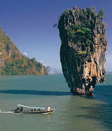
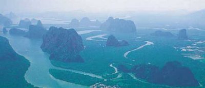
Believe It or Not Tabu Island was created because of anger. There is a local story that said : once upon a time, there was a fisherman who normally caught a lot of fish everyday for selling at the market. One day, as usual, he went to net, but it was not his day. He threw his net many, many times but got nothing. With great patience he tried again and again, but still got nothing. Consequently, he stared at the water looking for a waving pattern, he then threw his net again with a lot of hope. He kept his eyes fixed on the net when pulling it up, hoping some fish would be caught. Unfortunately he caught nothing but a nail. He became angry and threw the nail into the sea. Again with great concentration, he kept his eyes on the sea surface and tried his net once more. This time he threw his net as wide as he could with great hope of getting some fish. Then he pulled it up slowly as it was very heavy. He pulled it up with great care. At the end of the net he found the only thing caught was the same nail.He was so angry, he grasped his long knife and cut the nail with all his strength. The nail was cut in half. The nail was catapulted away and driven into the buttom of the sea standing up as you see it today.The area around Phangnga bay has a long history and is famed for its nature and beauty, especially Ko Tabu, Ko Panyi, Tham Lot and Khao Phing Kan. The rock art in this area has always been an important attractionThe popularity of the Phang Nga bay area led to the designation of the current area as a forest park in 1974, this was named Sri Phang Nga Forest Park. The Royal Forest Department then began to survey the area and realised it's heritage should be further protected by increasing the areas status to a national park.Ao Phangnga was created by Royal decree and gazetted under proclaimation number 98 section 64 of 29th April 1981. The park created covers an area of 400 sq.km, protects the largest area of this original primary mangrove forest remaining in Thailand. The park stretches from Muang Phangnga District to the coast at Takua Tung District. Over 80 % of the park is covered by the Andaman sea, with over 42 large and small islands, including such as Phra At Tao Island, Maprow Island, Boi Noi Island, Boi Yai Island, Rayaring Island, Phanak Island, Hong Island, Panyi Island, Phing Kan Island etc.
Geographical Features

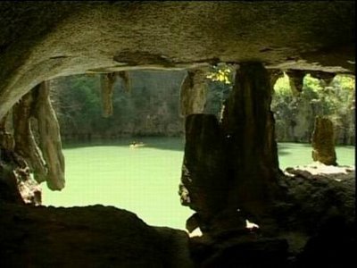
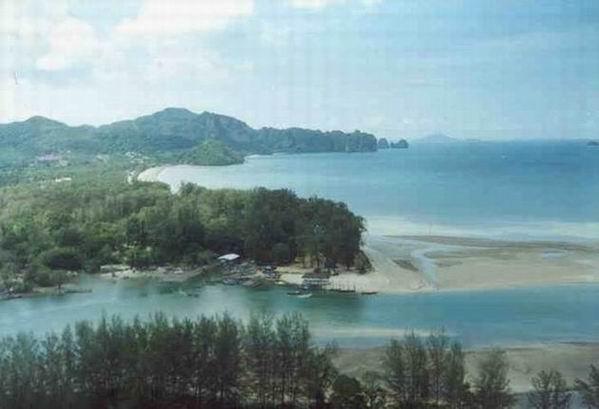
The topography of the park is strongly influenced by several faults, particulary the north-east trending of the Klong Marui fault. This offsets the eastern terrain from the central mountain ranges by a right lateral movement. This fault movement resulted in the formation of a large graben parallel to the fault. This graben is marked by the present bay.The high ground is produced by massive limestone blocks displaying classic karst scenery. These blocks extend southward into Phangnga bay where they form islands with vertical cliffs, mainly orientated in a north-south direction.Phangnga bay slopes seaward and is filled with tidal sediments. The bay itself is composed of large and small tidal channels which originally connected with the fluvial system of the mainland.The main tidal channels for instance Klong Ko Panyi, Khlong Phangnga, Klong Bang Toi and Klong Bo Saen all run in a north-south direction. They consist of several tidal creeks or tidal channel distributaries. Most of the tidal channels are meandering with well developed point bars. Mangrove forests grow around the whole area of the Phangnga bay, they differ in species depending on elavation and relative tidal range.The landward boundary of Phangnga bay is marked by a gentle erosion slope, limestone cliffs and transition forest between mangrove and upland forest which extends beyond the bay margin.
Weather Condition
The climate experienced in Phangnga Bay is tropical marine, with characteristic high rainfall and year round high temperatures. Thirty year records of Meteological Department of Thailand (1961-1990) collected at Takua Pa weather station indicate that rain is abundant in the south-west monsoon season from May to October. The average annual rainfall is 3,560.5 mm. and the average total rain days is 189 days. The temperature fluctuates between 23๐C and 32๐C. The average relative humidity is 83%.
Varieties of Plants and Wild Animals

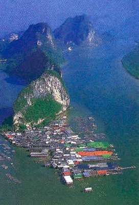
VegetationsPlant society in the Phang Nga Bay National Park could be divided into 3 types as follows :

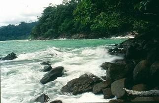
Mangrove ForestMangrove forest in the limestone mountain which found a lot of important plants in mangrove forest upto 12 types such as Rhizophora mucronata, Rhizophora apiculata, Xylocarpus granatum, etc. In addition, also found sea holly and a lot of Acrostichum aureum which growing up in the bank area or mud soil. Sea cyad is found a little bit in only the oponed area or destroyed area.

Mangrove forest in the cell and quatsite rock mountain which found the 7 important types of plants such as Rhizophora mucronata, Rhizophora apiculata, Xylocarpus granatum, etc. The other important low level plant found in this area is the dense growing sea holly.Mangrove forest in sandstone mountain which found a little bit of important plants because this area is very far from the main land. The 5 types of important plants here are Rhizophora apiculata, Sonneratia ovata, Aegialites rotundifolia, Xylocarpus granatum and Melaleuca leucadendron. In addition, samed would be found in the area adjacent to land forest which has the lower salt level.

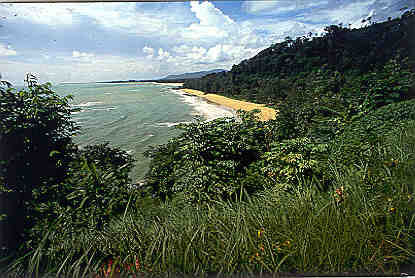
Land Forest, Defined as the evergreen forest which is rainforest and classified as follows :Land forest on the limestone mountain which could be found throughout the national park, there are 2 types :

the first is the forest on the plain land and the forest on the area so called Karst which is a valley area. They consist of the important plants such as Aporosa aurea, Hopea ferrea Heim. and Cassia alata Linn. Also, there are many important low level plants such as Fishtail palm.

The second is the forest on the moisture high area on a limestone mountain which consists of small and short plants such as Hopea ferrea Heim., Water wisteria, etc. Land forest on the cell quatsite rock mountain which found a lot of plants growing in the foot of mountain with very high moisture, we can find yang na woods scattering throughout this area and also find other important plants such as Schima wallichii (DC.) Korth., Bruguira gymnorrhiza, Carallia brachiata (Lour.) Merr., etc. while the low level plants found here are Bambusa arundinacea Wild, Glass, etc.Land forest on a sandstonewould be found on the slope area which has a lot of tree and not too high. There is a little bit of the low level plants here, most of them are grasses because of infertile soil. The important plants are Bruguira gymnorrhiza, Sesban, etc.
Aquatic Plant SocietyCould be classified as Padina, red alge, Halimida and including a lot of sea grass and plant planton.


Wild Animals, From survey could be classified as follows :Mammal animals, from survey could be found upto 27 types such as Macaca irus, Semnopithecus obscurus, Hylobates lar, etc. In addition, also found the important aquatic mammal animals such as Infonesian white dolphin, Malayan dolphin, Finless porpoise.Birds have been found totally 120 types, the important ones are Little heron, Pacific reef-egret, Little egret, etc.Reptiles have been found totally 26 types such as Siamese box terrapin, Pseudoxenodon macrops (Blyth), etc.Amphibians have been found 4 types such as Rana cancrivora, R. limnocharis, Rhaco phorusleucomystax, etc.Fishes consists of squat-headed hammer head shark sphyrna tudes, freshwater ater stingray dasyatis bleekeri, Moray eel, Puffer fish and many kinds of fish which live in the coral such as Butterfly fish and the economical valued fishes such as short-bodied mackerel.Marine LifeMarine life totals over 80 species: 24 species of fish, 14 species of shrimp, 15 species of crabs and another 16 species of manta-rays, sharks, and gamefish. In the bay, you will find blue crabs, swimming crabs, mud-skippers, humpback shrimp, mud-lobsters, pomfrets, jewfish, sole, anchovies, scad, rock cod, as well as rainbow cuttlefish, soft cuttlefish, musk crab, mackerels, spinefoots, groupers, black sea cucumbers, brain coral, staghorn coral and lastly flowerlike soft coral.The bay of Ao Phangnga National Park has a wealth of plankton, these are small plant and animal organisms that float at the water surface and serve as food for many species. The presence of large amounts of plankton is due to the shallowness of the water, rich nutrient supply and the higher temperatures found in the bay area. As the food resource is high, this makes a good nursery area for mothers of many species, which enter the bay to rear their young before returning to deeper water
Location and Journey

Address
Ao Phang-nga National Park80, Mu 1, Ban Tha Dan, Ko Panyi Sub-district,, Muang Phang Nga, Phangnga, Thailand 82000Tel. : 0 7641 1136, 0 7641 2188 Fax : 0 7641 3791
By Car
Once in Phang nga Town , go past on highway heading to Takua Thung District, pass the provircial Hall. About after 850 kilometers,at three junction,you turn left about 2.5 kilometers.
By Airplane
Takes a plane to Phuket International Airport, for about 1 hours 15 minutes, and then connect a car for 61 kilometers which takes time about 45 minutes to Phang Nga town. After that takes a minibus, Phang Nga-Tha Dan route, for 9 kilometers and will find it priot to Ta Dan 300 meters.
By Ship
Rent a boat or contact tour agent to handle for you.